The Blog
Search
Search
Exhibit
Fresh Photos
Editor's Choice Photos
Photoblogs
Upgrade
PRICING
Login
Start
Your 14-Day Free
Trial
Where you store your photos is as important as the photos you take.
Start Trial Now!
»
Wyoming Division HO Operation Layout
Wyoming Division HO Operation Layout
20 Scenery and Structures June 2020
By Verryl V Fosnight Jr
;
Jun 18, 2020
22 Photos
Share Album
Justified View
Flow View
Square View
Grid View
Journal View
Highlight View
Large Photo View
Slideshow
Proofing View
TV View
RSS
Verryl V Fosnight Jr
Featured
Gallery
About
Contact
Menu
Wyoming Division HO Operation Layout
Wyoming Division HO Operation Layout
20 Scenery and Structures June 2020
Jun 18, 2020
22 Photos
Share Album
Justified View
Flow View
Square View
Grid View
Journal View
Highlight View
Large Photo View
Slideshow
Proofing View
TV View
RSS
Featured
Gallery
About
Contact
Menu
×
Verryl V Fosnight Jr's Gallery
Wyoming Division HO Operation Layout
20 Scenery and Structures June 2020
https://verrylvfosnightjr.slickpic.com/albums/20-Scenery-And-Structures-June-2020/photo/#16989101
P1000675 FS PP per Std List
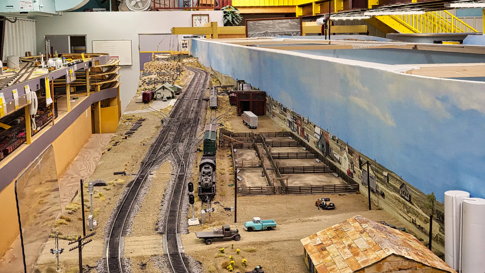
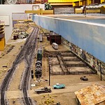
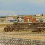
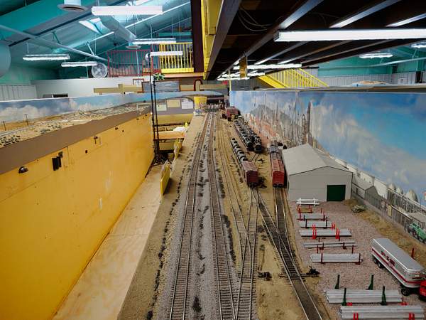
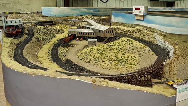
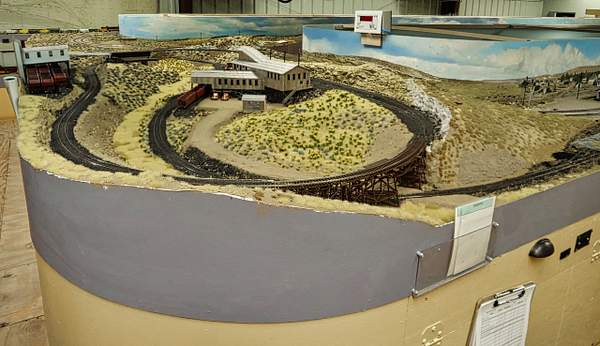
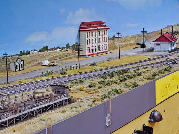
The center siding, or Harriman Siding, starting in Wamsutter, Wyoming and running west out of that location. under the camera is a Conaco oil distributor which usually gets its products for retail fuels and lubricants from either the Frontier refinery in Cheyenne, seen here on the bench to the left. The far western part of staging can be seen under the refinery. Staging is accessed through Cheyenne via the smaller helix seen in the upper left corner of this view. To enter staging past Frontier refinery in east Cheyenne is to travel to North Platte, Nebraska. NP is our shorthand location for all points east of Cheyenne: NP, Omaha, Council Bluffs, Chicago, or south of Nebraska through Marysville Kansas to Kansas City, St. Louis, and points south east.
https://verrylvfosnightjr.slickpic.com/albums/20-Scenery-And-Structures-June-2020/photo/#16989106
P1000677 FS per std list
The Harriman Siding seen from the west end. It is 18 feet long and able to hold the layouts longest trains of 30 cars pus caboose and locomotive and tender. Nearly all of the images in this album are assembled from multiple exposures of the scene. Multiple exposures are necessary to obtain good focus over the 45 to 60 foot long benches, because no lens system can be made that is capable of such a long "depth of field" when the camera is so close to the subject (that is inside the building. This assembly of multiple images is called "focus stacking," and is accomplished semi-automatically with a Panasonic Lumix G9 camera from about 30 exposures taken in a burst of an approximately 1 second long movie. There is more of this process in the "Photographing the Wyodiiv" album on this same album level.
https://verrylvfosnightjr.slickpic.com/albums/20-Scenery-And-Structures-June-2020/photo/#16989105
P1000679 PP per std list
A slightly different view of Wamsutter showing the time worn steel building of The Conoco Oil company. The large oil tanks are just out of view here. At each end of the center siding the right hand tracks have working dual head signals, with the lower head signaling the center siding.
https://verrylvfosnightjr.slickpic.com/albums/20-Scenery-And-Structures-June-2020/photo/#16989103
P1000683 FS PP per Std List
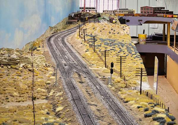
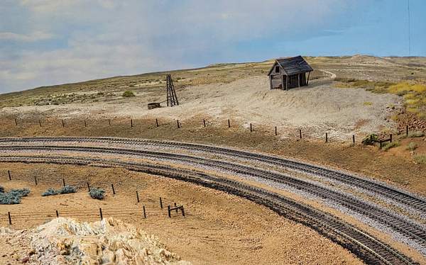
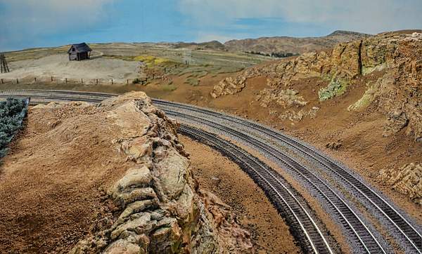
At the east end of the next bench, which models the so called dry prairie region called the Red Desert (between Wamsutter and Rawlins WY, the double tracks become three as we near the Rawlins WY station. We have an alternate main through all towns and industries, that is wherever any pickups and setouts might impede the flow of the 4 City trains we run (Cities of LA, San Francisco, St. Louis and Portland), or the few other mixed passenger trains we run each operating session. This is a ramshackle sheep herder's (?) shack and windmill that has been long since deserted.
https://verrylvfosnightjr.slickpic.com/albums/20-Scenery-And-Structures-June-2020/photo/#16989102
P1000681 FS PP per Std List
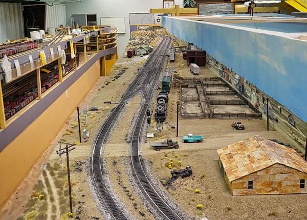
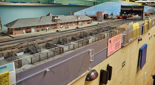
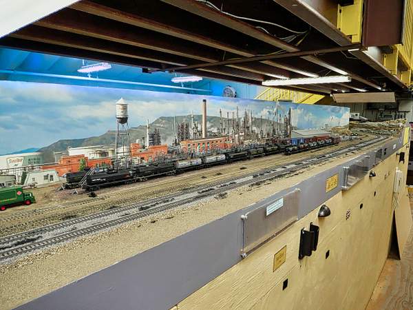
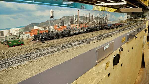
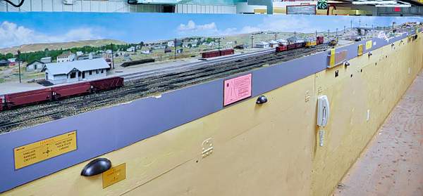
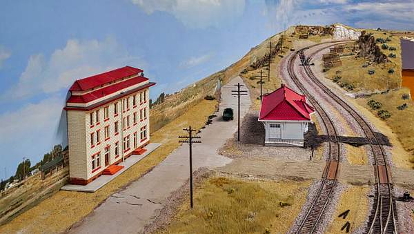
Traveling east from Wamsutter (on the next bench behind the left hand bench in this scene) we come to Rawlins, WY in distance. the Rawlins coal tower is behind the popcorn box (well, I never claimed to be perfect). We needed a bunch of containers for ballast, dirt (real Wyoming dirt), and sage brush and grass, so my buddies at Amazon sent me these popcorn barrels. Next toward the camera is the Rawlins freight house, and just out of town is the Sinclair Oil refinery, done as a backdrop scene, except for the 6 tank car long loading dock made from several Walthers kits. Rawlins and the next bench to the right straddle the 75 foot long building's centerline, and over it hangs the viewing mezzanine. It is easy to see that "hangs" is the correct term; the 7 x 75 foot mezzanine is held up by steel beams at either end and two huge steel arches from side wall to side wall spaced 25 feet apart.
https://verrylvfosnightjr.slickpic.com/albums/20-Scenery-And-Structures-June-2020/photo/#16989104
P1000685 FS PP per Std List POOR FS
A view of the cut just east of Rawlins (behind the camera).
https://verrylvfosnightjr.slickpic.com/albums/20-Scenery-And-Structures-June-2020/photo/#16989100
P1000688 FS PP per Std List Straighten cropTop
https://verrylvfosnightjr.slickpic.com/albums/20-Scenery-And-Structures-June-2020/photo/#16989107
P1000692 Per Look 061620 Std List
Rawlins freight house between the station and the Sinclair refinery. Again, note that there are no posts supporting the mezzanine.
https://verrylvfosnightjr.slickpic.com/albums/20-Scenery-And-Structures-June-2020/photo/#16989108
P1000694 Per Look 061620 Std List 3rd Mask
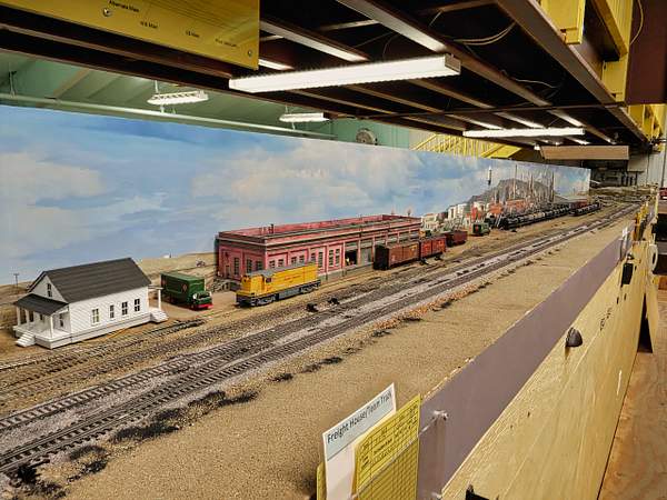
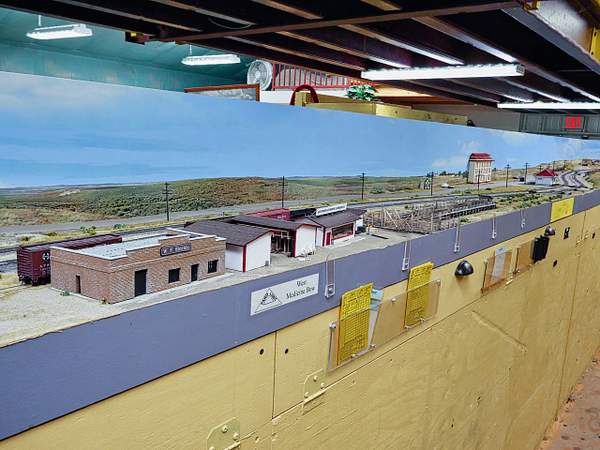
The Sinclair Refinery wholly on the backdrop, except for the loading dock and supply warehouse, the "metal" building in the distance. At the end of this bench the double track mains curve inside the Hanna WY coal mines (well 3 of about 20). They are behind the ridge at the far end of the bench. One of the east pair of steel members hanging from the overarching beams from which the mezzanine hands can be seen in the upper right corner of the photo.
https://verrylvfosnightjr.slickpic.com/albums/20-Scenery-And-Structures-June-2020/photo/#16989110
P1000696 Per Look 061620 Std List Roof Mask
The same scene but cropped.
https://verrylvfosnightjr.slickpic.com/albums/20-Scenery-And-Structures-June-2020/photo/#16989111
P1000698 Per Look 061620 Std List Mask Roof
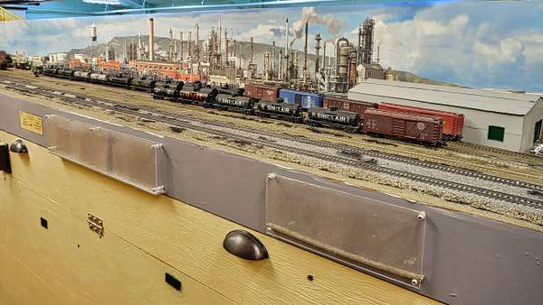
The Sinclair refinery with the supply warehouse at the east end of the facility. The hinged doors just below the fascia are the covers for built in wire trays that run the whole length of each bench. Some wire resides inside it, but we made a point to install in it all DCC circuit breakers and other critical parts that may have screw terminal wiring that may loosen. By the way, the copper feeder DCC wires are spot welded to the rails, not soldered.
https://verrylvfosnightjr.slickpic.com/albums/20-Scenery-And-Structures-June-2020/photo/#16989112
P1000700 Per Look 061620 Std List Roof Mask
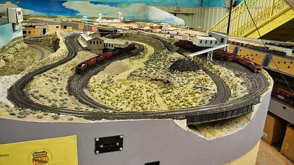
The mains can be seen curving inside this coal mine region just outside of Hanna, WY. they are on the other side of the backdrop just visible to the left.There are three mines and a supply warehouse in these two clusters of buildings. The curves are very tight in the mine region (a 4 x 8 foot layout on its own), so the Hanna coal drag job uses a 4 axle diesel to move cars down into the Hanna marshaling yard. That operator first takes "orders" (that is he counts the empty hoppers at the locations he serves, then makes up his train in his Hanna yard (just around the corner paralleling the mains), then uses a consist of RS-2's to deliver his loads and pick up his empties from all points east (Medicine Bow, Laramie, Laramie Tie Treating Plant, Harriman, and Cheyenne, including the coal tower, powerhouse, and Cheyenne City Coal, as well as Wycon Chemical in the eastern outskirts of Cheyenne.
https://verrylvfosnightjr.slickpic.com/albums/20-Scenery-And-Structures-June-2020/photo/#16989109
P1000702 Per Look 061620 Std List
https://verrylvfosnightjr.slickpic.com/albums/20-Scenery-And-Structures-June-2020/photo/#16989113
P1000704 Per Look 061620 Std List
This is about the same view of the Hanna Mines, but the focus stacking is not quite as sharp as the last photo. But then again, the package of scenery supplies has been removed. More importantly the beginning of the Hanna coal marshaling yard ladder can be seen. The town of Hanna is seen on the photo backdrop. The Hanna order sheet is on the clipboard ready for the next session. Allen Montgomery built all the buildings and the trestle.
https://verrylvfosnightjr.slickpic.com/albums/20-Scenery-And-Structures-June-2020/photo/#16989114
P1000708 Look 061620 Remove Color Cast
Coming out of the bend of the bench to the left the mains pass between the Hanna station and team track and the 4 track Hanna coal yard. The diesel yard switcher is on #3 and the RS-2 consist waits on its siding. Old box cars now used for storage are between the station and 3 UP Houses and storage sheds. The US 30 Highway overpass is next, and Medicine Bow WY is in the distance. US 30 is still known as the Lincoln Highway, promoted privately in 1912 by rich car enthusiasts led by Carl G. Fisher, a auto parts manufacturer. It was the first coast to coast highway, initially gravel and running 3,073 miles from Times Square in New York City west to Lincoln Park in San Francisco. In those days trains were the dominant means for cross country travel, and Fisher convinced his wealthy friends to promote auto travel. See the history for https://en.wikipedia.org/wiki/Lincoln_Highway
https://verrylvfosnightjr.slickpic.com/albums/20-Scenery-And-Structures-June-2020/photo/#16989116
P1000710 Look 061620 Std List plus 26 exp and 6 Temp
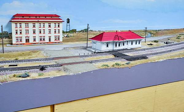
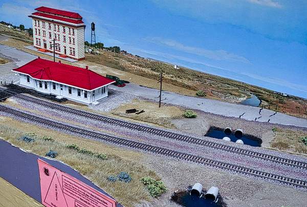
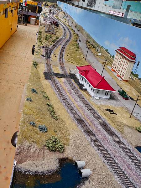
Medicine Bow Wyoming. A few spots to switch lead up to the station and across the Lincoln highway (still used today in a lot of Wyoming) is the stately and ornate Virginian Hotel with Victorian decor inside. It was named for the book "The Virginian: A Horseman of the Plains," a 1902 novel by the American author Owen Wister (1860-1938), set in Wyoming. It describes the life of a cowboy on a cattle ranch and is considered the first true fictional western ever written, aside from short stories and pulp dime novels.
https://verrylvfosnightjr.slickpic.com/albums/20-Scenery-And-Structures-June-2020/photo/#16989123
P1000736 Look 061620 Std List
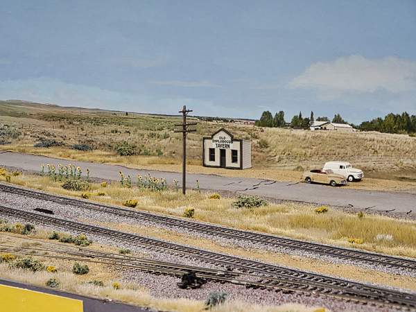
The tiny local bar, "The Diplodocus" named after a very large dinosaur discovered July 4, 1899 in Sheep Creek Quarry D, near Medicine Bow. This part of Wyoming is a prime location of dinosaur bone finds in the US.
https://verrylvfosnightjr.slickpic.com/albums/20-Scenery-And-Structures-June-2020/photo/#16989115
P1000712 Look 061620 Std List
The Virginian Hotel across the Lincoln Highway from the Medicine Bow depot with a freight room on the west end. Medicine Bow got its name because in fur trapper days (early 1800's) friendly tribes would assemble here and construct weapon bows, and powwow about cures of diseases. That medical knowledge was shared in hybrid speech between the Indians and early settlers.
https://verrylvfosnightjr.slickpic.com/albums/20-Scenery-And-Structures-June-2020/photo/#16989118
P1000716 Std List
Concerning medicine and doctors: All of my grandparents homesteaded in SE Colorado in 1917. My dad's parents came up from Oklahoma to escape a typhoid epidemic. Dad was born, on the homestead just weeks after his dad filed on it, and he was delivered by his father in 1917. My mom told of the time my dad as a baby was fussing and crying. An Indian woman asked what was wrong with him, and grandma said, "He's been fussing all day. The woman looked at him and pulled off his wet diaper, wrapped it around one finger and swabbed out his mouth. "Do that (so many) times a day she told his mother. He had trench mouth, and there were no doctors within easily 100 miles. Actually, he said the first time he ever was treated by a doctor was when he was 28. That was doctoring in the frontier days.
https://verrylvfosnightjr.slickpic.com/albums/20-Scenery-And-Structures-June-2020/photo/#16989119
P1000720 Look 061620 Std List
Looking back west from Medicine Bow to Hanna beyond the Lincoln Highway overpass. The old Lincoln Highway mostly followed the UP tracks which still mainly follows the original 1860's Transcontinental Railroad route from Council Bluffs to the Bay area. I am amazed that this route, found in the 1860's, is still the preferred route over the great majority of its length. US 30 followed it in 1912 on, and I-80 follows them both today, except for "shortcuts" up grades too steep for trains. And those latter day roads were built and improved in our modern age of airplane and satellite surveying!
https://verrylvfosnightjr.slickpic.com/albums/20-Scenery-And-Structures-June-2020/photo/#16989120
P1000724 Look 061620 Std List
This crossover was added to the layout, so west bound passenger trains could change tracks and go around slower freights. I think both buildings were drawn on AutoCad in 3D and printed on Lenny's 3D printer. I don't know who should get the most credit. Lenny is quite proficient at AutoCad and has tuned his 3D printer for very good performance, but he has taught Allen AutoCad (a daunting program) and helped him get on the printer. Kudos to both. There are many other 3D printed objects drawn and produced by them, originally just Lenny, but now both are hard at it.
https://verrylvfosnightjr.slickpic.com/albums/20-Scenery-And-Structures-June-2020/photo/#16990273
P1000738 Look 061620 Std List
Old Diplodocus Tavern, The Virginian Hotel, and the Medicine Bow station, looking east along UP mains and old Highway US 30.
19 Photos "Lightweight Ops Article"
21 Wyoming Division Scenery
03 Phase III Construction
04 Phase IV All Track Done--Details
05 Structures
06 Wyoming Division Operation Sessions
07 Fall Invitational Nov 12-14, 2016
08 First Annual Winter Invitational
09 Backdrops Signals Scenery
10 Backdrops Signals Scenery
11 2017 Winter Invitational Meet BBQ
12 2017 Winter Invitational Meet Ops
13 Winter Invitational 2017 Lenander Photos
14 2018 Fourth Winter Invitational
16 Spring Invitational (5th) Ops Meet
17 Photographing the WyoDivOps 12/14/19
18 Ops 121419
19 Photos "Lightweight Ops Article"
20 Scenery and Structures June 2020
21 Wyoming Division Scenery
22 ABS Signals
23 Structures During Pandemic
24 Post Pandemic August 2022
25 How We Operate-Fall 2022
Scroll To Top
Slideshow
By Email
Link:
Copy Link
?
Close Sidebar
Verryl V Fosnight Jr
PRO
Follow
Following
Unfollow
Contact
Photo Details
Date
Dimensions
Size
File
Camera
ISO Speed
Exposure
Aperture
Focal Length
Flash
Display Image Quality
Tags
Comments
No comments yet...
All fields are required, fill in the form.
Comment successfully added.
Comment
New comments notifications
Audio Mute
Prev
Play
Next
Shuffle
Include
Privacy and cookie policy
This site uses cookies to enhance your browsing experience, serve personalized content, and analyze traffic. By continuing to use this site you agree to
use of cookies and stewardship of your data
.


No comments yet...
All fields are required, fill in the form.
Comment successfully added.
Comment